
Pix4Dmapper Pro
Desktop software for professional drone-based mapping. Pix4Dmapper software automatically converts images…
Desktop software for professional drone-based mapping. Pix4Dmapper software automatically converts images…

SimActive’s Correlator3D software is a patented end-to-end photogrammetry solution for the generation of high-quality geospatial data…

Precise aerial image triangulation with exceptional performance. Geo-reference blocks of aerial imagery based on the advanced and unique image…
January 2016. DAT/EM Systems International released the 7.2 edition of DAT/EM software products…
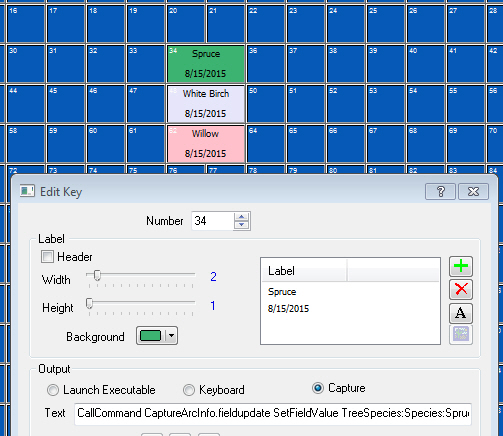
November 2015. Are you setting the same field values again and again? You can set Keypad, digitizer or Summit’s Custom…

Create powerful deliverables from images collected with UAS (Unmanned Aircraft Systems) aerial mapping and surveying systems…

Vector Factory by Infoterra SGSA, part of Airbus Defence and Space: Collect vectors using the Vector Factory editing environment…

Sweco Nederland developed a DAT/EM Capture™ module as an interface between the Summit Evolution™ stereoplotter and dg DIALOG BGT…
RhinoCapture by SARL Rhinoterrain: Collect buildings using Rhino software connected to the DAT/EM Summit Evolution stereoplotter…

In addition to being the best 3D modeling software for projects of any size and complexity for architects and engineers, MicroStation® provides…